The Skirrid
The Skirrid, known more formally as Ysgyryd Fawr in Welsh (meaning "Great Skirrid" or sometimes translated as "shattered mountain"), is a distinctive and dramatic hill rising to approximately 486 metres above sea level in the Black Mountains of southeast Wales, near the town of Abergavenny in Monmouthshire. Despite the database entry listing it under "Central England," it sits firmly within Wales, just a few miles northeast of Abergavenny, and is one of the most recognisable landmarks in the region. Its immediately striking feature is its unusual profile: a great landslip has carved away the southeastern flank of the hill, leaving a bold, almost ecclesiastical silhouette that has fired the imagination of visitors and locals for centuries. The National Trust owns and manages much of the hill, ensuring public access to one of the most spiritually and historically resonant summits in the Welsh Marches.
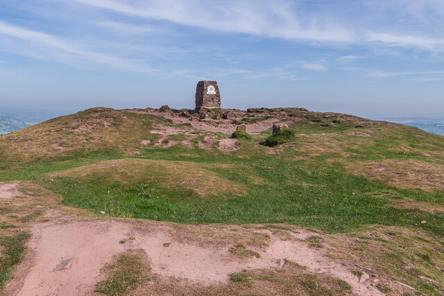
What makes the Skirrid extraordinary is the remarkable legend attached to its fractured shape. Christian tradition in the area holds that the great landslide which sheared away part of the hillside occurred at the precise moment of the Crucifixion, the earth itself splitting in grief at Christ's death. This belief gave the hill its longstanding alternative name of the Holy Mountain, and for centuries it was regarded as sacred ground. Pilgrims would make their way to the summit chapel dedicated to St Michael the Archangel, whose ruined foundations can still be found at the top. The soil from the hillside was reputedly blessed and was used for centuries in burials across the region, with mourners carrying small bags of Skirrid earth to be placed in coffins, believing it would protect the souls of the dead. This practice was documented well into the early modern period and speaks to the deeply embedded spiritual power the hill held in local consciousness.
The physical experience of climbing the Skirrid is one of quiet drama. The ascent from the car park near Llanvihangel Crucorney is relatively straightforward but rewarding, rising through mixed woodland and bracken-covered slopes before the path steepens toward the summit ridge. The landslip hollow on the southeastern side is visible throughout and lends the hill an almost otherworldly quality, as though a giant hand has taken a great bite from it. At the top, the ruined outline of St Michael's chapel sits exposed to whatever weather is blowing across the mountains, and on a clear day the panoramic views take in the whole sweep of the Black Mountains to the west, the Brecon Beacons beyond, the Sugarloaf and the Blorenge to the southwest and west, and the rolling patchwork of the English border country to the east. The summit can be wonderfully lonely and atmospheric, especially in low cloud or mist, when the chapel ruins emerge from the grey like something from a ghost story.
The surrounding landscape is quintessential Welsh Marches country, a borderland of layered history and extraordinary natural beauty. The small village of Llanvihangel Crucorney lies at the foot of the hill and is itself notable for containing the Skirrid Inn, one of the most historically significant pubs in Wales. The inn claims to be among the oldest in the country and carries its own dark legends, including the tradition that Judge Jeffreys used an upper room as a courthouse during the Monmouth Rebellion of 1685, with condemned men reportedly hanged from a beam in the stairwell. Whether every detail of this story holds up to strict scrutiny, the building is genuinely ancient and atmospheric. Abergavenny, just a few miles to the southwest, is the natural base for exploring the area and offers good amenities, a market, a castle and museum, and strong connections to the wider Brecon Beacons National Park. The Sugarloaf, another National Trust hill, and the broader Black Mountains ridge walks are all within easy reach.
Practically speaking, there is a small National Trust car park on a lane off the B4521 near Llanvihangel Crucorney, from which the main path up the Skirrid begins. The walk to the summit and back typically takes between two and three hours at a moderate pace, covering roughly four kilometres round trip with around 330 metres of ascent. The path can be muddy and steep in places, and sturdy footwear is strongly recommended year-round. The hill is accessible in all seasons, but spring and autumn offer particularly fine conditions, with summer providing the longest daylight and clearest views and winter bringing the possibility of frost, ice and dramatic low light that adds to the hill's brooding character. There is no charge for access, as it is managed as open land by the National Trust, though donations are always welcomed. Dogs are generally welcome but should be kept under control around livestock.
One of the most haunting and lesser-known aspects of the Skirrid is the way it sits at the intersection of Welsh, English and Norman influences, a liminal place in the fullest sense. The Norman lords who built nearby Abergavenny Castle would have looked up at this hill constantly, and its sacred status was certainly known to them. The dedication of the summit chapel to St Michael follows a long tradition of placing Michaeline chapels on high, exposed places — Mont Saint-Michel in Normandy and St Michael's Mount in Cornwall follow the same pattern, and there is something in the pre-Christian impulse to honour high ground that these dedications absorbed and preserved. The name Ysgyryd is debated by scholars, with some linking it to a Welsh root meaning "to shake" or "to shatter," which fits both the physical geology and the theological legend with remarkable neatness. Few hills in Britain carry quite so much layered meaning in such a compact and approachable summit.