Bowscale Tarn
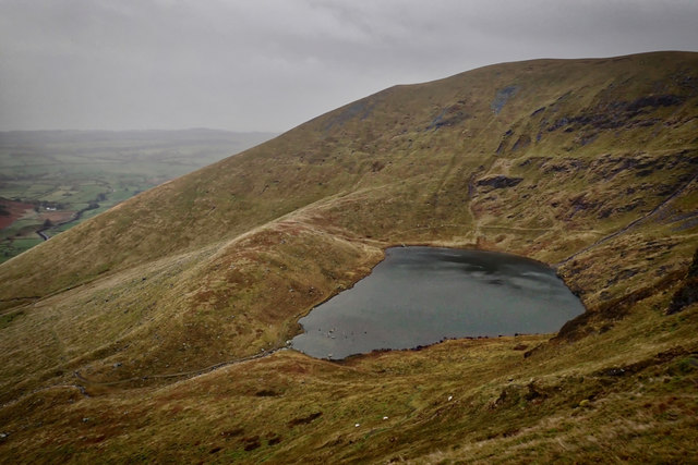
Bowscale Tarn is a remote glacial corrie tarn nestled in the northern fells of the Lake District, sitting at an elevation of approximately 1,550 feet on the northeastern slopes of Bowscale Fell. This dark, circular mountain pool occupies a dramatic glacially-carved hollow, creating one of the most atmospheric and isolated bodies of water in the Cumbrian uplands. The tarn is fed by springs and mountain streams, maintaining its water level throughout most of the year, and it holds a special place in Lakeland folklore as the legendary home of two immortal fish and, according to some tales, the resting place of the crown of the kings of Cumberland.
The tarn's most famous legend concerns two immortal trout said to inhabit its depths, a story documented by various Lake District writers over the centuries. Local tradition held that these fish were deathless and would appear only on special occasions. This supernatural association may have ancient origins, possibly connected to pre-Christian beliefs about mountain tarns as sacred or otherworldly places. The tale was sufficiently well-known that it was recorded by early Lakeland historians and has become part of the rich tapestry of Cumberland folklore. Some versions of the legend claim that the tarn is bottomless, a common folk belief about isolated mountain pools that likely arose from their dark, peaty waters that make depth perception difficult.
The physical setting of Bowscale Tarn is striking and somewhat austere. The tarn sits within a perfect horseshoe-shaped corrie, with steep rocky crags rising directly from its southern and western shores. These dark cliffs, composed of Skiddaw slate, create a natural amphitheatre that gives the location an enclosed, almost secretive character. The water itself is typically dark and reflective, coloured by peat from the surrounding moorland, and on calm days it mirrors the surrounding crags with exceptional clarity. The atmosphere here can be remarkably still and quiet, broken only by the occasional call of a raven or the whistle of the wind across the fell tops.
During winter months, ice often forms around the tarn's edges, and snow can linger in the corrie well into spring due to its north-facing aspect and elevation. The surrounding vegetation is typical of upland Lakeland environments, with rough grasses, sedges, and patches of heather dominating the landscape. The approach paths cross open moorland characterized by tussocky grass and occasional boggy sections, giving visitors a genuine sense of wild fell country. In summer, the area supports various upland bird species, and the patient observer might spot wheatears, ring ouzels, or peregrine falcons hunting from the crags above.
The tarn is located within the Cumbrian Fells, specifically in the northern section of the Lake District National Park, positioned between the more popular routes up Blencathra to the southwest and the quieter northern fells. The nearest village is Mungrisdale, a small agricultural community about two miles to the north-northwest, which sits along the road between Penrith and Keswick. The broader landscape is characterized by rolling moorland and rounded slate fells, quite different in character from the more rugged central Lakeland peaks. This northern section of the national park tends to be quieter and less visited than areas around Windermere or Keswick, offering those who make the effort a more solitary mountain experience.
To reach Bowscale Tarn, most visitors park in Mungrisdale village, where there is limited roadside parking near the Mill Inn. From the village, a well-defined footpath leads south and then climbs steadily up the valley of Bowscale Beck. The walk to the tarn covers approximately two miles with an ascent of around 1,000 feet, taking most walkers between 45 minutes to an hour and a half depending on fitness and conditions. The path can be wet and muddy in places, particularly after rain, and the final approach to the tarn involves some steeper ground. Good walking boots are essential, and the route is not suitable for pushchairs or wheelchairs due to the terrain and gradient.
The best time to visit Bowscale Tarn depends largely on what experience you seek. Summer offers the most reliable weather and the longest daylight hours, making navigation easier and the walk more pleasant, though even in summer the higher fells can be cool and windswept. Spring brings fresh growth and nesting birds, while autumn can provide spectacular colours in the bracken and heather. Winter visits are possible for experienced hillwalkers with appropriate equipment, but ice, snow, and limited daylight hours mean extra caution is required. Weather in the northern fells can change rapidly at any time of year, so visitors should be prepared with appropriate clothing, food, water, and basic navigation skills.
One particularly interesting aspect of Bowscale Tarn is its geological formation. Like many Lake District tarns, it occupies a corrie (or cirque) that was carved by glacial action during the last ice age. As glaciers formed in the hollow and began to rotate and move downhill, they eroded the bedrock in a characteristic pattern, creating the steep back wall and the rounded hollow that now contains the tarn. The lip of the corrie acts as a natural dam, trapping water in the depression. This process has created numerous similar features throughout the Lake District, but Bowscale Tarn's relatively pristine condition and dramatic setting make it one of the more photogenic examples. The Skiddaw slate bedrock, which dominates this part of the Lake District, is among the oldest rock in the national park, dating from the Ordovician period approximately 450 million years ago.