Dinas Dinlle
Dinas Dinlle is an ancient Iron Age hillfort and coastal promontory situated on the western shores of the Llŷn Peninsula in Gwynedd, north-west Wales. Perched dramatically above a long sandy beach and overlooking Caernarfon Bay, this windswept earthwork is one of the most evocative and atmospherically remote prehistoric monuments in Wales. The site consists of a roughly oval fortified summit ringed by substantial ramparts and ditches, the remains of which are still clearly visible despite significant erosion caused by centuries of coastal retreat. What makes it particularly compelling is the combination of its historical depth, its mythological associations, and the raw physical drama of its setting — standing here, the Irish Sea stretches away to the west, Snowdonia rises behind you to the east, and on clear days the full arc of the Llŷn Peninsula curves southward in a sweeping panorama.
The fort itself dates from the Iron Age, broadly between around 500 BCE and the Roman period, though the site was almost certainly occupied and modified across multiple centuries. It is classified as a scheduled ancient monument in Wales, reflecting its national significance. The earthen ramparts, which likely once supported timber palisades, enclose a raised interior platform from which the occupants would have commanded outstanding views in all directions — a strategic position that was clearly deliberate, offering both defence and visibility over maritime approaches. Archaeological work at Dinas Dinlle has revealed evidence of occupation and activity consistent with a defended settlement of some regional importance, though much of what might have been the outer extent of the fort has now tumbled into the sea as the soft glacial deposits of the headland have been steadily eaten away by wave action.
In Welsh mythology and legend, Dinas Dinlle has a compelling presence. The name itself is often translated as the "fort of Lleu" or the "fortress of Lleu Llaw Gyffes," connecting it to one of the most remarkable figures in the Mabinogion, the collection of medieval Welsh tales that preserve some of the oldest strands of Celtic mythology in Britain. Lleu Llaw Gyffes — whose name means something like "Lleu of the Skilful Hand" — is a solar deity-like hero figure, nephew of the magician Gwydion and son of Arianrhod, whose own fortress, Caer Arianrhod, is traditionally associated with a submerged reef visible offshore to the north. According to the Fourth Branch of the Mabinogi, Lleu was raised near this coastline, and the association of the site with his name gives it a mythological gravity that sits comfortably alongside its physical commanding presence. Whether or not the medieval storytellers were describing a genuine folk memory of the place, the connection has given Dinas Dinlle a cultural resonance that extends far beyond its archaeological importance.
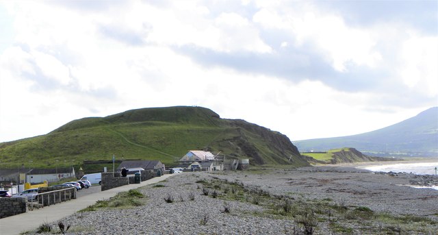
In person, Dinas Dinlle is a place of considerable physical character. The headland rises perhaps thirty metres above the beach in a blunt green hump, and climbing its grassy flanks on a breezy day you are immediately struck by the wind, which seems almost constant here, rolling in off the bay and flattening the rough grass. The rampart ridges are still bold and unmistakable even to an untrained eye — you can walk along their crests and feel the deliberate engineering of the landscape underfoot, the ditch falling away on one side and the ground rising on the other. The summit interior is open and flat, with views that reward every direction you turn. Below, the beach stretches away in both directions, a long pale crescent of sand and pebbles that is popular with local families in summer but can feel genuinely wild and empty in the off-season. The sound is largely of wind and surf, with the occasional small aircraft overhead from the nearby Caernarfon Airport, which sits just a short distance to the north-east along the coast road.
The surrounding area is rich in interest for any visitor. The village of Dinas Dinlle itself is a small, quiet seaside settlement with a handful of houses, a car park, and basic visitor facilities including public toilets and a small café. The beach is popular for swimming and kite-flying, and the coastal path connects it into a broader network of walking routes along the Llŷn Peninsula. Caernarfon, the historic walled town with its magnificent UNESCO World Heritage-listed castle, is only about eight kilometres to the north-east and makes an obvious and rewarding companion destination for any visit. To the south, the Llŷn Peninsula extends toward Abersoch and Aberdaron, offering some of the most unspoiled scenery in Wales. The peaks of Snowdonia, including the summit of Yr Wyddfa (Snowdon), are clearly visible on good days across the Menai Strait and the hills behind Caernarfon.
Visiting Dinas Dinlle is straightforward and free. There is a public car park at the bottom of the headland within easy walking distance of the fort, and the climb to the top is a short but moderately steep walk on grass — suitable for most reasonably mobile visitors, though the uneven terrain and lack of formal paths on the earthworks themselves mean it may be challenging in wet conditions or for those with mobility difficulties. Dogs are welcome and the open landscape makes it a popular spot for walkers with pets. The best time to visit is arguably the shoulder seasons of spring and autumn, when the summer crowds have thinned, the light has a particular golden quality over the bay, and the fort's atmosphere feels more authentically remote. Winter visits can be spectacular on clear days but the exposure to westerly gales can be ferocious. There is no entrance fee and no formal heritage site infrastructure on the monument itself — it is open farmland and coastland managed as a scheduled monument but accessible freely to the public.
One of the more poignant and fascinating aspects of Dinas Dinlle is the story of its ongoing disappearance. The headland is composed largely of glacially deposited material — sands, gravels and clays laid down during the last Ice Age — and these are deeply vulnerable to erosion by the sea. Studies and historical comparisons suggest that the fort was once substantially larger, and that significant portions of what would have been the outer defences and perhaps parts of the interior have already been lost to the waves over the past century alone. This slow dissolution adds a bittersweet quality to a visit: you are looking at something ancient that is quietly, inexorably being reclaimed by the sea, and the ramparts that remain are all the more precious for their fragility. It is a place where mythology, prehistory, and geology converge on a windswept headland, and that combination makes it one of the genuinely memorable and undervisited sites in Wales.