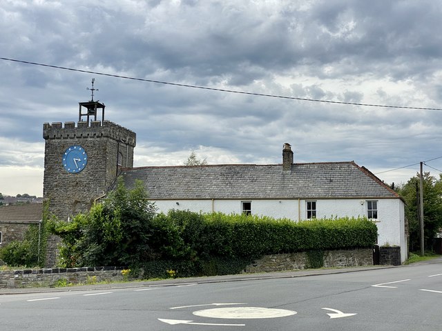
Pandy Farm and Clock
Pandy Farm and its associated clock sit within the Brecon Beacons National Park in Powys, south Wales, placing them in one of the most celebrated upland landscapes in Britain. The coordinates at 51.75418, -3.39148 place this location in the vicinity of the village of Llangynidr or the broader Usk Valley corridor, a stretch of Wales characterised by glacially sculpted ridges, stone-walled farmsteads and the broad meander of the River Usk. The term "pandy" itself is a Welsh word meaning a fulling mill — the kind of water-powered industrial structure that was once essential to the Welsh wool trade — and its presence in a place name is a reliable indicator that some form of textile processing once took place here, linking the farm to a pre-industrial economic tradition that shaped rural Wales for centuries.
The fulling mill heritage implied by the pandy name connects this locality to the broader story of the Welsh woollen industry, which reached its height between the sixteenth and nineteenth centuries. Farmers across upland Wales would raise sheep on the common land of the beacons, shear them in summer, and take the raw fleece to local mills where water-driven hammers would beat and compress the cloth to improve its density and weather resistance. A farm bearing the pandy designation would have sat adjacent to, or incorporated, such a structure, likely powered by one of the many fast-flowing hill streams that descend from the Beacons escarpment into the Usk and its tributaries. Over time, as industrial production moved to the valleys of Glamorgan and Monmouthshire, these small rural mills fell silent, and many of their buildings were absorbed into working farmsteads, leaving only the name as evidence of what once happened there.
The clock associated with the place is an intriguing detail that sets Pandy Farm apart from the many other former fulling mill sites in the region. Prominent clocks on rural farm buildings are relatively unusual in Wales, and where they do exist they often speak to a particular moment of agricultural improvement or Victorian estate investment, when a landowner or prosperous tenant farmer would commission ornamental additions to a working building as a mark of status and modernity. A farm clock of this kind would typically be set into a gable wall or stable yard facade, visible from a distance and intended to regulate the working day of labourers who would otherwise have had no reliable means of timekeeping. In isolated upland communities, such a clock would have served a genuinely practical communal function, and its survival to the present day gives the farm a quietly distinguished character.
In physical terms, this part of the Brecon Beacons feels ancient and unhurried. The surrounding hills carry a smooth, rounded profile typical of Devonian Old Red Sandstone, their flanks covered in purple moor-grass and bracken that shifts colour dramatically through the seasons, from the burnt amber of late autumn to the vivid green flush of spring. Farm buildings in this area tend to be constructed from local grey-brown sandstone with thick walls and small windows that speak to the demands of a wet, wind-exposed climate. The ambient sounds are those of a working upland landscape — the cry of red kites overhead, the rush of water in nearby streams, the distant calling of sheep on the common. On still mornings low mist frequently collects in the valley bottoms before burning away to reveal wide views northward toward the Brecon Beacons escarpment and southward toward the coalfield edge.
The broader area around these coordinates sits within the Usk Valley, a corridor of exceptional natural beauty that also carries significant historical layering. The Roman road known as the Via Julia Montana passed through this general region connecting the legionary fortress at Isca (Caerleon) with the upland interior, and the landscape retains a sense of deep time that rewards attentive visitors. The nearby village of Llangynidr is known for its picturesque medieval bridge over the Usk and its connections to the Monmouthshire and Brecon Canal, which runs through the valley and draws walkers and boaters in considerable numbers. Crickhowell, a few miles to the southeast, offers a fuller range of amenities including independent shops, cafes and the remains of a Norman castle, and makes a natural base for exploring the wider area.
Visitors approaching Pandy Farm should be aware that this is a working agricultural property rather than a formal tourist attraction, and access to any private farmland should be sought only with the landowner's permission. The public rights of way network in this part of Powys is well developed, however, and it is entirely possible to walk through the surrounding landscape on established footpaths that provide views of the farm and its setting without causing any disturbance. The area is best visited in late spring or early autumn when the weather is typically more settled, the light is warm and low, and the moorland vegetation is at its most dramatic. Those arriving by car will find the roads through this valley narrow and require patience, while the nearest meaningful public transport is limited, making private transport or cycling the most practical approach for most visitors.
What makes Pandy Farm genuinely worth seeking out is the way it embodies a quietly persistent rural continuity. Unlike many heritage sites that present history as something packaged and interpreted, a place like this simply carries its past within its fabric — in the name that records a vanished industry, in a clock face that once organised the rhythms of working lives, and in the landscape of stone walls and open hill that has looked broadly similar for generations. For anyone with an interest in Welsh rural history, vernacular architecture or the slow archaeology of working landscapes, it represents exactly the kind of unsung detail that gives a region its true depth and texture.