Pen-y-Gaer
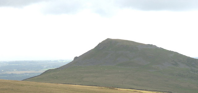
Pen-y-Gaer is an Iron Age hillfort situated on a prominent hilltop in the Llŷn Peninsula of northwest Wales, near the village of Llanaelhaearn in Gwynedd. Occupying a commanding position on the slopes of Yr Eifl — the dramatic triple-peaked mountain range also known in English as The Rivals — the hillfort stands as one of the most impressive and well-preserved prehistoric defensive structures in Wales. Its elevated position, typically around 350 metres above sea level on the hillside below the main summits of Yr Eifl, offers extraordinary panoramic views over the Llŷn Peninsula, Caernarfon Bay, and on clear days across the Irish Sea toward the mountains of Ireland. This combination of dramatic natural scenery and substantial archaeological remains makes Pen-y-Gaer a genuinely rewarding destination for those with an interest in Welsh prehistory and mountain landscapes alike.
The site dates primarily from the Iron Age, roughly spanning the period between around 600 BCE and the Roman conquest of Britain in the first century CE. Like many Welsh hillforts, it was likely used as a defended settlement and a focal point for the surrounding community, offering protection and a visible statement of territorial power. The local tribe in this region were the Ordovices, a Celtic people who fiercely resisted Roman expansion into northwest Wales. The hillfort's presence on the Llŷn Peninsula places it within a rich tapestry of prehistoric activity, as the peninsula was an important route and settlement zone throughout the Bronze and Iron Ages. The precise nature of life within the fort — whether it was continuously occupied or used seasonally and in times of conflict — remains a matter for archaeological interpretation, but structural remains including ramparts and ditches survive visibly on the ground.
The physical character of the site is defined by its rugged, windswept atmosphere. The hillside setting on Yr Eifl is one of rough moorland grass, heather, and bare rock, shaped by millennia of exposure to Atlantic winds sweeping in from the Irish Sea. The ramparts, constructed from locally quarried stone rather than earth and timber, give the site a distinctively Welsh character — the stonework, though tumbled and weathered, remains legible as a defensive circuit when you walk its perimeter. The views are stunning in every direction: the jagged ridgeline of Yr Eifl rises above, while below the peninsula stretches away in a patchwork of fields and coastline. The sound environment is dominated by wind and the calls of upland birds, giving the place a sense of remote antiquity that is hard to replicate at more heavily managed heritage sites.
One of the most remarkable features of the immediate area is the proximity of Tre'r Ceiri, another hillfort situated just over a kilometre to the northeast on the highest summit of Yr Eifl at around 485 metres. Tre'r Ceiri — which translates from Welsh as "Town of the Giants" — is widely considered one of the best-preserved hillforts in Britain and indeed in Europe, with its drystone ramparts still standing to considerable height and the outlines of dozens of stone roundhouses clearly visible within its walls. Tre'r Ceiri was occupied into the Romano-British period, long after Roman conquest, making it an extraordinary example of continuity. The proximity of these two defended hilltop sites within the same mountain massif speaks to the strategic and cultural significance of Yr Eifl in prehistoric Wales. Visitors to Pen-y-Gaer often combine it with a walk to Tre'r Ceiri on the same outing.
The surrounding landscape of the Llŷn Peninsula is itself a designated Area of Outstanding Natural Beauty, characterised by a quietness and remoteness that sets it apart from busier parts of Snowdonia to the northeast. The village of Llanaelhaearn lies at the foot of Yr Eifl and provides the most common starting point for walks up to the hillforts. The coastal scenery nearby is spectacular, with the beaches of Nant Gwrtheyrn — a former Welsh quarrying village now operating as a Welsh language centre — nestled in a dramatic cwm on the northern flank of Yr Eifl. The whole area carries deep associations with Welsh cultural identity, and the peninsula is one of the strongest Welsh-speaking areas remaining in Wales, giving the landscape a linguistic as well as a scenic distinctiveness.
Practically speaking, Pen-y-Gaer is accessed on foot from car parking areas near Llanaelhaearn or from the minor roads that skirt the base of Yr Eifl. The terrain is rough upland walking, and sturdy footwear, waterproofs, and a map are advisable. The site itself is open access land managed under Cadw (the Welsh Government's historic environment service) and Natural Resources Wales frameworks, meaning there is no admission fee and no formal visitor infrastructure beyond waymarked paths. The best times to visit are late spring through early autumn, when weather is more stable and the days are long enough to take in both Pen-y-Gaer and Tre'r Ceiri comfortably. Mist and low cloud are common on Yr Eifl even in summer, and wind can be intense. Winter visits are possible for experienced walkers but require care. The site is not wheelchair accessible given the mountain terrain.
A fascinating detail about this cluster of hillforts on Yr Eifl is that the name itself — Yr Eifl, or "The Rivals" in common English usage — may actually be a corruption of an older Welsh form, with the original meaning possibly being closer to "the forks" or "the prongs," a reference to the mountain's distinctive triple-peaked profile rather than any sense of competition. The landscape's layers of meaning — geological, prehistoric, linguistic, and cultural — give Pen-y-Gaer a depth that rewards slow, attentive visiting. Standing within its ancient stone circuit on a clear day, with the Irish Sea glittering to the west and the bulk of Snowdonia massing to the east, it is possible to feel a genuine connection to the communities who chose this dramatic place as their home and stronghold more than two thousand years ago.