Pencoed y Foel
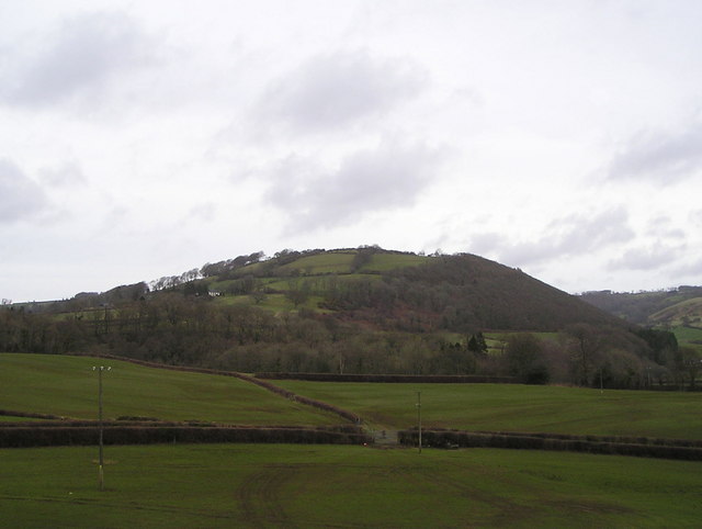
Pencoed y Foel is a farmstead and elevated settlement site situated in the rural heartland of Ceredigion, in west Wales. The coordinates place this location in the undulating upland countryside southeast of Aberaeron and north of Lampeter, in a landscape that is quintessentially mid-Welsh in character — a mosaic of improved pasture, rough grazing land, scattered woodland, and small family farms connected by narrow lanes. The name "Pencoed y Foel" is a Welsh place-name of considerable descriptive power: "pen" meaning head or top, "coed" meaning wood or trees, and "moel" (or "foel" through soft mutation) meaning bare hill or bald hill — giving a combined sense of "the wooded head of the bare hill" or "the top of the wood on the bare hill," which is a remarkably accurate description of the kind of transitional zone between open upland and sheltered valley-side woodland that characterises this part of Ceredigion.
The area sits within the broader landscape of the Aeron Valley and its surrounding hinterland, a region that has been farmed continuously since at least the early medieval period. Much of Ceredigion was part of the ancient Welsh kingdom of Ceredigion, later absorbed into the larger kingdom of Deheubarth, and the upland farmsteads in this area often trace their origins to medieval bond townships and free-holding arrangements that defined Welsh rural society before the Norman penetration of the lowlands. While Pencoed y Foel itself does not appear to be a scheduled monument or nationally listed heritage asset under Historic Environment Wales records with high-profile national recognition, it sits in a region dense with prehistoric and early medieval remains, and isolated upland farmsteads such as this frequently preserve evidence of long agricultural continuity in their field patterns, hedgebank structures, and building fabric.
Physically, the location at just over 52 degrees north latitude and sitting at a modest but noticeable elevation above the valley floor means the land here has the feel of the true Welsh upland fringe — neither the dramatic mountain country of Snowdonia nor the gentle lowland of the coastal strip, but something in between: open enough to feel exposed in wind and rain, yet enclosed enough by hedgerows and small cwms to offer shelter. The sounds characteristic of this landscape are those of curlew and lapwing in spring, the constant background of wind moving through rushes and rough grassland, and the occasional distant lowing of cattle on surrounding farms. The views from elevated ground nearby extend westward toward Cardigan Bay on clear days, with the Cambrian Mountains forming the eastern skyline.
The surrounding area is rich in small lanes, public footpaths, and bridleways that crisscross the farmland of this part of Ceredigion. The village of Llangeitho lies a few miles to the northeast, notable as the site of a celebrated eighteenth-century Methodist revival associated with the preacher Daniel Rowland, one of the most significant figures in Welsh religious history. Tregaron, the market town of the upper Teifi valley, lies further east and serves as a hub for exploring the Tregaron Bog (Cors Caron) National Nature Reserve. Aberaeron to the northwest is a handsome Regency-planned harbour town on the coast. This positioning means that Pencoed y Foel sits in a genuinely rewarding area for rural exploration even if the farmstead itself is a quiet, working agricultural place rather than a formal visitor attraction.
Access to this location is via the network of minor roads that characterise the Ceredigion interior, and visitors should be prepared for single-track lanes with passing places, particularly when approaching from the valley bottoms. There is no dedicated visitor infrastructure — no car park, no interpretive signage, and no formal access beyond public rights of way that may cross or border the land. The best approach for those wishing to explore the broader area is to use the Ordnance Survey Explorer map for this region (OL23 Brecon Beacons or the relevant Ceredigion sheet) to identify public footpath routes. The best time to visit the wider area is late spring through early autumn, when the lanes are passable, the paths are dry enough for comfortable walking, and the long-distance views are at their clearest. Winter visits are possible but the upland lanes can become difficult in ice and snow, and the exposed character of the land makes conditions challenging.
One of the more quietly fascinating aspects of places like Pencoed y Foel is what they reveal about the extraordinary density and continuity of Welsh-language place-naming in the rural landscape. Every farm, every field, every hollow and hillock in this part of Wales carries a name that encodes centuries of local observation — the nature of the soil, the history of ownership, the character of the terrain in different seasons. The name Pencoed y Foel is not a relic but a living description, still accurate today, of a place where upland gives way to sheltered slope and where trees thin out as the ground rises toward open moorland. This linguistic and topographic layering is, in many ways, the most remarkable thing about such locations — they are living archives of a way of understanding and naming landscape that stretches back into the early medieval period and beyond.