Penlle'r Castell
Penlle'r Castell is an Iron Age hillfort situated on a prominent ridge in the Brecon Beacons area of South Wales, positioned at an elevation that commands sweeping views across the surrounding upland landscape. The site sits within the historic county of Breconshire, in what is now the Brecon Beacons National Park, and represents one of the many prehistoric defensive enclosures that punctuate the high ground of this part of Wales. Though not among the most extensively excavated or formally interpreted hillforts in Wales, it holds genuine archaeological and landscape significance, offering a tangible connection to the Iron Age communities who chose this windswept ridge as a place of defence, habitation, or ritual prominence.
The name Penlle'r Castell is Welsh in origin, translating roughly as "the head of the castle place" or "the top of the castle enclosure," with "pen" meaning head or top, "lle'r" relating to place, and "castell" denoting castle or fortified enclosure. This naming convention reflects the Welsh tradition of applying the word "castell" to prehistoric as well as medieval defensive works, and it signals that local communities retained an awareness of the site's artificial and deliberately constructed character long after its original occupants had gone. The fort likely dates to the Iron Age, broadly the period between roughly 800 BC and the Roman conquest of southern Wales in the first century AD, though without comprehensive excavation it is difficult to assign precise dates to its construction or use phases.
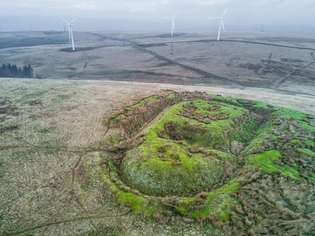
The physical remains at Penlle'r Castell consist primarily of earthwork ramparts — banks and ditches that would originally have formed a formidable defensive perimeter. Like many upland Welsh hillforts, the site relies on the natural topography of the ridge to augment its artificial defences, with steep natural slopes providing protection on certain sides while the earthworks reinforced the more vulnerable approaches. The interior of the enclosure, where structures of timber or wattle-and-daub once stood, has long since returned to rough moorland vegetation, and today the site is carpeted in upland grasses, heather, and the kind of coarse moorland flora typical of the South Welsh uplands at altitude.
Standing at Penlle'r Castell, the experience is defined above all by the enormous sense of openness and exposure. The wind is almost a constant companion on the ridge, sweeping across from the west and carrying with it the particular acoustic quality of the open moor — a low, persistent rush broken only by the calls of skylarks in summer or ravens year-round. On a clear day the panorama stretches across a vast arc of upland terrain, with the higher summits of the Brecon Beacons visible to the northeast and the Swansea Valley and lowlands opening up to the south and southwest. The views would have made the site an extraordinary natural observation post, capable of monitoring movement across a wide stretch of territory, which almost certainly factored into its selection by Iron Age communities.
The surrounding landscape is characteristic of the upland fringe between the industrial South Wales valleys and the wilder, emptier interior of the Brecon Beacons. The area around these coordinates is crossed by moorland tracks and minor roads, and the site sits within a working upland farming landscape of rough grazing. The nearby Swansea Valley and the communities of the upper Neath and Tawe rivers are within relatively close reach to the south. The moorland here has a quality of in-betweenness — neither the dramatic rocky escarpments of the central Beacons nor the deep forested valleys below, but a rolling, open terrain that has its own austere beauty, particularly under the dramatic skies that the maritime Welsh weather produces.
Visiting Penlle'r Castell requires a degree of self-sufficiency and willingness to navigate upland terrain without formal visitor infrastructure. There is no car park, interpretation board, or managed trail specifically serving the site. Access is typically on foot across open moorland, and appropriate walking boots, waterproofs, and a map or GPS device are strongly advisable. The Brecon Beacons National Park, now rebranded as Bannau Brycheiniog National Park, covers the broader area, and the general right of access to open land in Wales under the Land Reform provisions means that walkers can generally approach the site across the open hill. The best seasons to visit are late spring through early autumn, when the days are longer and the ground conditions less waterlogged, though the site has a stark and memorable character in winter too, when low cloud and frost transform the ridge into something genuinely elemental.
One of the quietly compelling aspects of Penlle'r Castell is how thoroughly it has been returned to the landscape rather than being preserved as a formal monument with barriers and signage. It is the kind of place that rewards those who seek it out precisely because it demands something of the visitor — a walk, a degree of navigation, a tolerance for wind and weather — and gives back in proportion to that effort. The earthworks, when you stand among them, communicate a very direct sense of human labour and intention across more than two thousand years of time. Whoever built this place moved enormous quantities of earth and stone to mark out a defended space on a high Welsh ridge, and the physical evidence of that effort remains quietly legible in the landscape today.