Twyn y Garth
Twyn y Garth is a prominent hill and moorland summit located in the Mynydd Epynt range in Powys, mid-Wales. The name is Welsh in origin, with "twyn" meaning a rounded hill or mound and "garth" referring to an enclosure or ridge, together evoking the sense of a rounded hilltop ridge — a description that fits the landscape well. The summit sits at approximately 474 metres above sea level and forms part of the broad, open upland plateau that characterises the Epynt moorland, a largely treeless and remote expanse that dominates this part of mid-Wales between the Brecon Beacons to the south and the hills of Radnorshire to the north. It is the kind of place that rewards those who seek out quieter, less-visited corners of the Welsh uplands, offering wide skies, sweeping views and a sense of solitude that is increasingly rare in the British countryside.
The Mynydd Epynt plateau on which Twyn y Garth sits has a complex and at times poignant history. The area has been inhabited and worked since prehistoric times, and the broader Epynt upland contains numerous Bronze Age cairns, standing stones and earthworks, evidence that these hills held significance for early communities long before recorded history. The landscape was shaped over centuries by Welsh pastoral farming communities, whose smallholdings and ffridd fields climbed the hillsides in the traditional pattern of Welsh upland agriculture. However, the most significant historical disruption came in 1940 when the War Office compulsorily acquired approximately 40,000 acres of the Epynt plateau for military training purposes, forcibly displacing around 219 people from 54 farms and smallholdings. This clearance effectively erased a living Welsh-speaking rural community, and the social and cultural loss has never fully been recovered. The area remains the Sennybridge Training Area today, administered by the Ministry of Defence, and this military presence fundamentally shapes access to much of the Epynt range, including the area around Twyn y Garth.
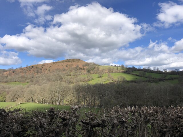
In physical terms, Twyn y Garth presents itself as a smooth-backed moorland hill, its summit and flanks covered in rough upland grasses, rushes, heather and boggy ground typical of the Welsh upland plateau. There are no dramatic rocky outcrops or crags here; the character is one of gentle, rolling elevation, with the hill rising gradually from the surrounding moorland. The ground underfoot can be wet and tussocky, particularly after rain, and the walker needs appropriate footwear for boggy terrain. On a clear day the silence at the summit is profound, broken mainly by the wind moving across the open moorland, the occasional call of a skylark or red kite, and perhaps the distant rumble of military vehicles or aircraft from the training ranges. The light here, especially on overcast days, has that particular quality of Welsh upland weather — soft, diffuse and changeable, lending the landscape an austere beauty.
The surrounding landscape is one of the most dramatically open and under-visited moorland environments in Wales. The Mynydd Epynt plateau stretches for miles in every direction, and on a clear day the views from elevated ground near Twyn y Garth encompass a wide panorama including the Black Mountains and Brecon Beacons to the south, the Cambrian Mountains to the north and west, and the border hills of Radnorshire to the northeast. The small town of Builth Wells lies to the northeast, and Brecon is accessible to the south. The Upper Usk Valley and the Ysgir Valley are the main drainage features flanking the Epynt plateau, and the surrounding country is defined by deep-cut river valleys contrasting with the broad, bare summits above. The A470 trunk road, one of the main arteries of mid-Wales, passes within reasonable distance to the east, connecting Brecon and Builth Wells.
Visiting Twyn y Garth requires awareness of the military training area that covers much of Mynydd Epynt. The MOD has designated a network of public rights of way and open access land within and around the Sennybridge Training Area, and there are waymarked routes — most notably the Epynt Way, a long-distance circular route of around 130 kilometres — that allow walkers to legally and safely enjoy the upland. Red flags are flown when live firing is taking place, and when flags are flying access to the range areas is prohibited. Visitors are strongly advised to check firing times in advance through the MOD's Sennybridge Range website or by telephone before heading onto the higher ground. The nearest settlements with any facilities are Garth (a small village to the north) and Llangammarch Wells, while Builth Wells offers a broader range of services. The area is best accessed by private vehicle, as public transport in this part of mid-Wales is limited. The best times to visit are late spring through early autumn when the ground is drier, the days are long and the upland wildlife — including red kites, curlews and skylarks — is most active and visible.
One of the more poignant and fascinating dimensions of the Epynt plateau is the ongoing effort to preserve the memory of the Welsh-speaking community that was expelled from it in 1940. Local historians and Welsh cultural organisations have worked to record oral histories, farm names and the place names that stud the landscape — names like Twyn y Garth itself — as a form of living memorial to what was lost. The Welsh language place names of the Epynt are particularly rich and descriptive, each one encoding centuries of local knowledge about terrain, ownership and use, and their survival in official records and on maps is considered culturally significant. The clearance of 1940 is sometimes referred to in Welsh cultural discourse as one of the great injustices done to Welsh rural communities in the modern era, comparable in its cultural impact — if not its scale — to the Highland Clearances in Scotland. Walking these hills today, it is possible to feel the weight of that absence alongside the stark natural beauty of the place.