Twyn-y-Gaer
Twyn-y-Gaer is an Iron Age hillfort situated on a prominent ridge in the Brecon Beacons National Park in Powys, Wales. The site occupies a commanding hilltop position at an elevation that affords sweeping views across the surrounding upland landscape, making it a place of both archaeological significance and natural beauty. It belongs to a class of prehistoric defended settlements that are remarkably well represented across Wales and the wider British Isles, though Twyn-y-Gaer is considered a particularly fine example of its type within the Black Mountains and Brecon Beacons region. The fort's preserved earthworks draw walkers, history enthusiasts, and those with a general interest in the deep human past of the Welsh uplands, offering a tangible and largely undisturbed connection to communities who lived here well over two thousand years ago.
The hillfort dates primarily to the Iron Age, broadly spanning the period from around 600 BC to the Roman conquest of this part of Wales in the first century AD. The people who constructed and inhabited Twyn-y-Gaer were likely part of the tribal group known to later Roman writers as the Silures, a confederation of Celtic peoples who occupied south-east Wales and who became famous for their fierce and prolonged resistance to Roman military expansion. The defences at Twyn-y-Gaer consist of the characteristic earthwork ramparts of the period — banks and ditches thrown up to protect the settlement within — and the site shows evidence of multiple phases of construction and modification over the centuries, suggesting sustained occupation and ongoing investment in its defences. While no dramatic battle accounts are specifically attached to this particular fort, the broader landscape of the Brecon Beacons contains numerous hillforts that together speak to a society deeply concerned with territorial control, communal identity, and protection during an unsettled era.
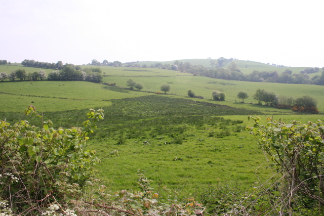
In physical terms, Twyn-y-Gaer presents itself as a series of grass-covered earthen ramparts forming an oval or roughly rounded enclosure on the hillcrest. The banks, though softened by centuries of weathering and the growth of turf and bracken, remain impressively visible and can be traced with relative clarity by anyone walking the perimeter. The interior of the fort is open ground, largely covered in rough upland grasses and, in season, heather and bracken. Standing within the enclosure, one is immediately struck by the sense of exposure and elevation — the wind is almost always present, often strong, carrying the clean, peaty scent of moorland. In summer, the site buzzes with insects and the calls of upland birds; in winter or in low cloud, it takes on a bleaker, more austere quality that is compelling in its own way.
The landscape surrounding Twyn-y-Gaer is quintessentially that of the central Brecon Beacons and the Usk Valley hinterland. The fort sits in a position from which the broad valley of the River Usk can be glimpsed to the south and east, with the town of Crickhowell lying not far distant in that direction. The Brecon Beacons proper, including the high sandstone ridges of Pen y Fan and Corn Du, rise to the west, while the Black Mountains extend to the east. This is a landscape of sheep-grazed hills, ancient trackways, isolated farmsteads, and stone-walled fields on the lower slopes, with raw open moorland taking over at higher elevations. The general area is extraordinarily rich in prehistoric remains, with standing stones, burial cairns, and other hillforts all within relatively close range, placing Twyn-y-Gaer within a much broader prehistoric cultural geography.
Visiting Twyn-y-Gaer requires a degree of effort and self-reliance typical of upland walking in Wales. There is no dedicated car park or formal visitor infrastructure at the site itself; access is on foot across open hillside, and walkers should come equipped with appropriate footwear, waterproofs, a map and compass or reliable GPS device, and sufficient provisions. The nearest settlement of any size is Crickhowell, a charming market town on the A40 road roughly to the south-east, which offers accommodation, cafés, and a useful base for exploration of the surrounding area. The best approach to the fort depends on the route chosen, but paths across the open hillside form the typical means of access. The site is on open access land and there is no admission charge. The most rewarding visiting conditions tend to be in late spring or early autumn, when the weather is more settled, the days long enough for comfortable walking, and the vegetation at a manageable level. Summer can bring bracken that obscures the lower earthworks, while winter visits, though more demanding, offer starker views and a profound sense of solitude.
One of the quietly fascinating aspects of Twyn-y-Gaer is how it exemplifies the sheer density of prehistoric activity in this part of Wales. The Brecon Beacons as a whole contain one of the highest concentrations of archaeological field monuments in Britain, and a site like Twyn-y-Gaer can feel overlooked and intimate precisely because it sits among so many neighbours, from the more widely known Roman fort at Y Gaer near Brecon to the various Neolithic and Bronze Age monuments scattered across the uplands. The name itself, "Twyn-y-Gaer," is Welsh and translates roughly as "the hillock" or "the knoll of the fort," with "twyn" meaning a rounded hillock or mound and "gaer" being a commonly used element in Welsh place names derived from the Latin "castra" (fort or fortified place), reflecting the long interweaving of Welsh, Latin, and Celtic linguistic traditions across this landscape. That etymological layering — a Welsh name that carries a Latin-derived word, applied to a prehistoric Celtic site — is itself a small window into the complex cultural history of Wales.