Spout Linn
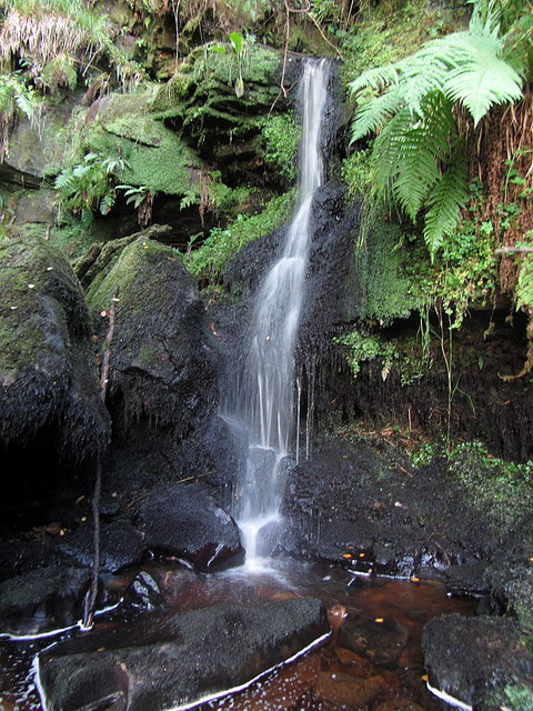
Spout Linn is a secluded waterfall located deep within Kielder Forest in Northumberland, England, where Spout Sike tumbles over a rocky ledge in one of the most remote and heavily forested areas of the country. The falls are situated at OS grid reference NY610947, corresponding to coordinates 55.245392, -2.614168, placing them in the northern reaches of what is England's largest forest. The waterfall itself is modest in scale but characterful, with the waters of Spout Sike descending over a series of rock steps in a narrow, wooded clough. The exact height of the falls varies with interpretations of where the cascade begins and ends, but the main drop is typically described as being in the region of 10 to 15 feet, though the total descent over the rocky course may be somewhat greater. The flow is heavily dependent on recent rainfall, as with most waterfalls in the Border uplands, and can range from a gentle trickle during dry summers to a vigorous torrent following periods of sustained precipitation.
Spout Sike is a small tributary stream that rises on the moorland slopes within Kielder Forest, draining a modest catchment of coniferous plantation and remnant moorland. The stream follows a northward course through increasingly steep-sided terrain before joining the larger watercourse system that eventually feeds into Kielder Water, the vast reservoir that dominates this landscape. The bedrock underlying the waterfall consists of sedimentary rocks from the Carboniferous period, including sandstones, siltstones, and mudstones that have been shaped by millennia of erosion. The geology of the area reflects the ancient depositional environments of river deltas and shallow seas that once covered this part of northern England, and the layered nature of these rocks contributes to the stepped character of the waterfall.
The surrounding landscape is dominated by the commercial forestry of Kielder Forest, which was extensively planted by the Forestry Commission from the 1920s onwards as part of a national afforestation programme. The area where Spout Linn is located would have been open moorland or rough pasture before the arrival of the conifers, part of the vast Border uplands that historically supported only scattered farming communities and extensive sheep grazing. The forest now consists primarily of Sitka spruce and other coniferous species, creating a dense canopy that has transformed the ecology of the region. Despite the dominance of plantation forestry, the forest harbours a variety of wildlife, including roe deer, red squirrels, and a growing population of pine martens. The reservoir and forest together form an International Dark Sky Park, recognized for the exceptional quality of its night skies.
Access to Spout Linn requires some determination, as the waterfall is not located on any major waymarked trail and lies in a relatively inaccessible part of the forest network. Visitors typically need to use forest tracks and then navigate through woodland to reach the stream and waterfall, and the precise route may vary depending on forestry operations and seasonal conditions. The nearest public road access points are along the minor roads that penetrate the forest from the south, though parking options are limited to informal layby spaces or designated forest car parks some distance from the falls. Ordnance Survey maps at 1:25,000 scale are essential for navigation, and visitors should be prepared for pathless terrain, potentially boggy ground, and the challenges of navigating through commercial forestry where tracks may not always be clearly marked or maintained.
The nearest substantial facilities are found at Kielder village, several miles to the south, where there is parking, visitor information, and basic amenities associated with Kielder Water and the surrounding recreational infrastructure. The reservoir itself, completed in 1982, is the largest artificial lake in northern Europe by capacity and has become a major focus for outdoor recreation, though Spout Linn remains far more obscure than the better-known attractions around the waterside. Those venturing to the waterfall should come equipped for remote countryside walking, with appropriate footwear, navigation tools, and awareness that mobile phone coverage is sparse or non-existent in much of Kielder Forest. The forest is criss-crossed by numerous tracks used for forestry operations, and conditions can change with harvesting cycles, replanting, and track maintenance.
There is little recorded history or folklore specifically associated with Spout Linn itself, reflecting both its modest scale and its location in what has historically been sparsely populated territory. The name "linn" is a Scots and northern English dialect term for a waterfall, pool, or precipice, derived from the Gaelic "linne," and its use here reflects the linguistic and cultural heritage of the Borders region that straddles England and Scotland. "Spout" similarly refers to the rushing or spouting nature of the water, a common descriptive element in waterfall names throughout northern Britain. The wider Kielder area has a more substantial history, including as a contested borderland during centuries of Anglo-Scottish conflict, and later as a sparsely populated farming district before its transformation through twentieth-century afforestation and reservoir construction.
The transformation of this landscape through forestry and the creation of Kielder Water has created an environment that is both artificial and yet valuable for certain forms of biodiversity, particularly species adapted to forest and freshwater habitats. The area supports breeding birds including crossbills, siskins, and various raptors, while the reservoir and streams provide habitat for otters and aquatic invertebrates. For visitors interested in seeking out lesser-known waterfalls in northern England, Spout Linn offers an opportunity to explore the quieter corners of Kielder Forest, away from the more popular trails and viewpoints around the reservoir shore, though it requires a willingness to navigate challenging terrain and accept the uncertainties inherent in visiting such remote natural features.