Water Ling Force
Water Ling Force is a modest waterfall located in the Yorkshire Dales, positioned south of the village of Bainbridge in Wensleydale. The falls occur on a small unnamed watercourse that drains the moorland slopes in this part of the dale, with the OS grid reference SD943866 placing it in the landscape of rolling hills and traditional drystone-walled fields characteristic of this section of the northern Pennines. While not among the more celebrated cascades of the Yorkshire Dales, Water Ling Force represents a typical example of the numerous small waterfalls that punctuate the tributary streams feeding into the main valley systems of this National Park landscape.
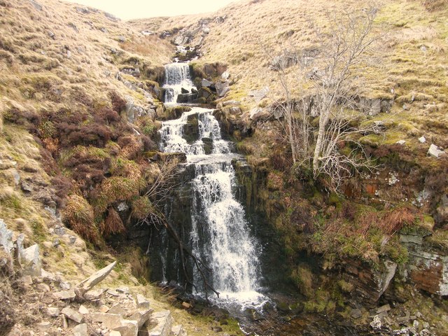
The physical character of Water Ling Force reflects the geology of the area, which is dominated by the Yoredale Series of rocks—alternating bands of limestone, sandstone, and shale laid down during the Carboniferous period. These strata create the characteristic stepped topography of the Yorkshire Dales, with harder limestone and sandstone layers forming resistant ledges over which streams cascade, while softer shale bands erode more readily. The waterfall likely exhibits this stepped character, with water tumbling over one or more rock ledges rather than forming a single vertical plunge. The flow regime would be typical of small upland streams in this region, varying considerably with seasonal rainfall and being particularly vigorous during wet periods in autumn and winter, while potentially reducing to a trickle during dry summer months.
The unnamed watercourse feeding Water Ling Force rises somewhere in the moorland south of Bainbridge, gathering water from the peat-covered slopes and improved pastures that characterize the higher ground in this area. These small tributaries play a vital role in the hydrology of Wensleydale, eventually contributing their waters to the River Bain or directly to the River Ure. The catchment area would be relatively small, comprising sheep-grazed pastures and patches of moorland vegetation, with the water quality influenced by the upland agricultural practices of the area. Such streams are important both ecologically and in terms of the traditional field drainage patterns that have shaped the landscape over centuries of farming.
Bainbridge itself is a historic village with Roman origins, having been the site of the fort of Virosidum, which guarded the Roman road over the Pennines. The village maintains its traditional character with a broad village green and remains an important settlement in upper Wensleydale. While Water Ling Force may not feature prominently in documented folklore or historical records, the landscape around Bainbridge is rich in traditional stories and agricultural heritage. The surrounding area has been shaped by generations of hill farming, with the pattern of fields, walls, and tracks reflecting centuries of human interaction with this upland environment. Small waterfalls like this would have been familiar landmarks to local farmers and shepherds, and may have played roles in boundary definitions or as watering points for livestock.
The landscape surrounding Water Ling Force is characteristic of the transitional zone between the valley floor and the higher moorlands of the Yorkshire Dales. The area supports a mix of improved grassland for grazing, traditional hay meadows where they survive, and patches of rougher vegetation on steeper slopes and wetter ground. The botanical interest in such areas often includes upland wildflowers, and the streams themselves provide habitat for invertebrates and occasionally brown trout in the larger watercourses. Birdlife typical of upland Yorkshire would be present, including species such as curlews, lapwings, and skylarks in the open country, while the stream corridors might attract grey wagtails and dippers. The overall ecology reflects the managed agricultural landscape of the Dales, with biodiversity dependent on the continuation of traditional, extensive farming practices.
Access to Water Ling Force would typically involve walking from Bainbridge village, which offers limited parking around the village green or along roadside locations where permitted. The village has basic facilities including a shop and pub, making it a practical base for exploring the surrounding countryside. The public rights of way network in this area is well-developed, with numerous footpaths crossing the fields and moorland south of the village. Ordnance Survey maps would be essential for locating the waterfall precisely, and walkers should be prepared for typical upland conditions including potentially muddy paths, stiles, and exposure to weather. The walk to the falls would likely pass through working farmland, so visitors should follow the Countryside Code, keeping dogs under control and closing gates behind them.
The area around Bainbridge forms part of the Yorkshire Dales National Park, designated for its outstanding landscape quality and cultural heritage. While Water Ling Force itself may not be a major tourist destination, it forms part of the intricate network of natural features that contribute to the overall character and appeal of this protected landscape. The falls would be of particular interest to those exploring the lesser-known corners of Wensleydale, seeking solitude away from the more popular honeypot sites, or pursuing specific interests such as waterfall photography or the study of fluvial geomorphology in limestone country.